
Pacific Coast Highway vs. Blue Ridge Parkway: Two Great American Road Trips Compared
Scenic drives, landscapes, and traveler experiences compared between California's coastal route and Appalachia's mountain byway.
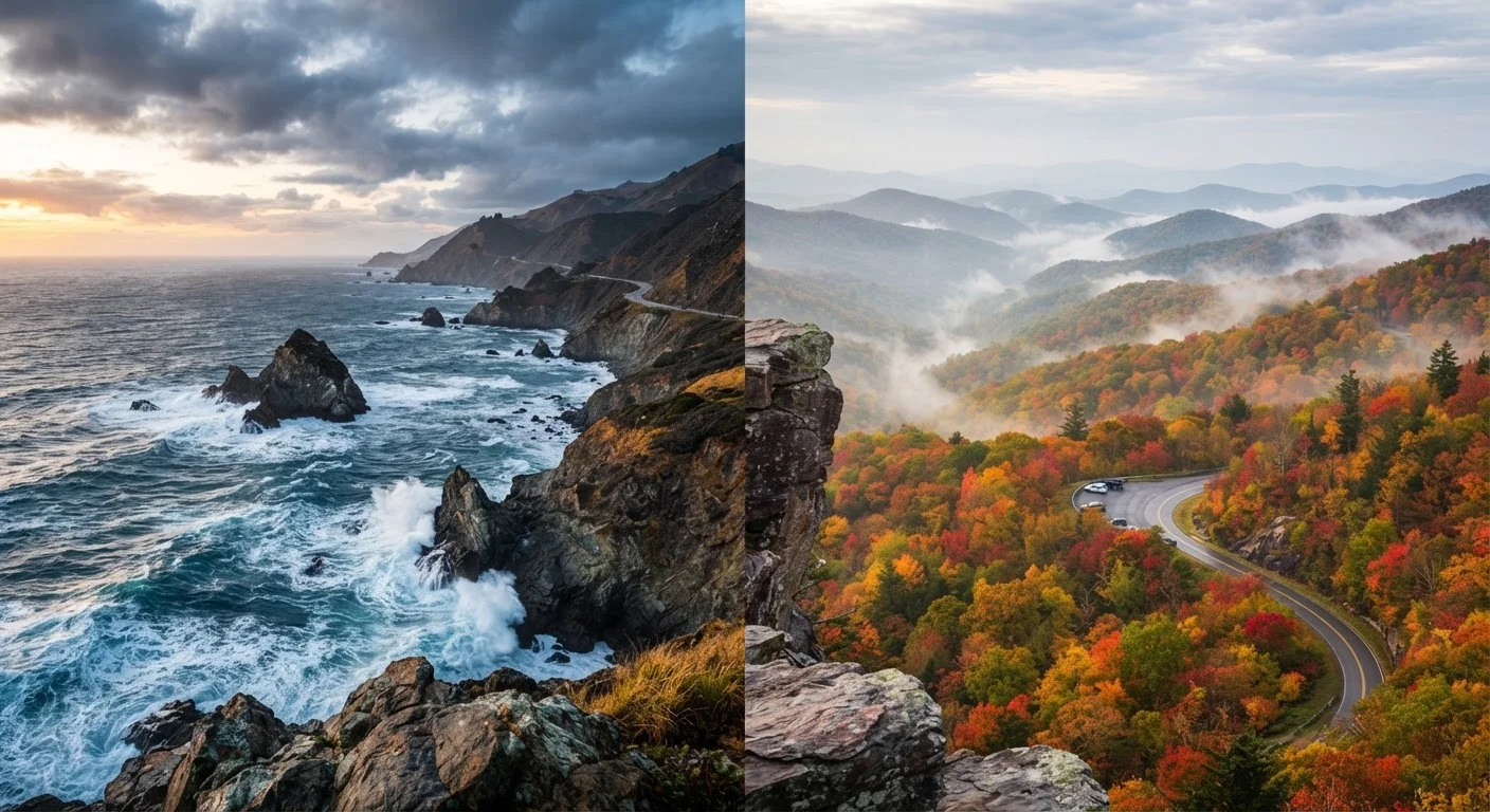
Photo: CoralScripts.com | Explore, Discover, Engage editorial
—— In This Article
Key Takeaways
- PCH offers ocean panoramas and coastal towns; the Blue Ridge Parkway delivers mountain solitude and Appalachian culture.
- The Blue Ridge Parkway spans 469 miles across Virginia and North Carolina, while PCH's most scenic stretch covers roughly 655 miles.
- PCH is best experienced spring through fall; the Blue Ridge Parkway peaks in late September through October for foliage.
- Both routes have speed-limit restrictions that encourage slow, scenic travel rather than fast throughways.
- Lodging and fuel availability differ significantly between the two routes, requiring different levels of advance planning.
Route Overview: Scale, Terrain, and Character
The Pacific Coast Highway — officially California State Route 1 — hugs the California shoreline for roughly 655 miles between the Los Angeles area and Leggett in Mendocino County. Its character is defined by constant motion: the Pacific Ocean filling the western horizon, rocky headlands dropping into surf, and the occasional tunnel carved through coastal bluffs. The drive demands attention — not just because the scenery commands it, but because the road itself, particularly through Big Sur, is narrow and winding.
The Blue Ridge Parkway stretches 469 miles from Shenandoah National Park in Virginia to Great Smoky Mountains National Park in North Carolina, operating as a unit of the National Park Service. Where PCH is dynamic and edge-of-continent dramatic, the Parkway is enveloping — a ridgeline corridor lined with hardwood forest, rhododendron thickets, and pastoral overlooks. The Parkway's posted speed limit never exceeds 45 mph, and the absence of commercial traffic or signage creates an almost meditative atmosphere.
For travelers curious about how each route fits within the broader landscape of US road-tripping, our guide to America's national park regions provides useful context on the ecosystems and attractions anchoring each end of both routes.
Scenery and Natural Highlights
PCH's signature landscape is the meeting of land and sea. Big Sur — roughly 90 miles of coastline between Carmel and San Simeon — represents the route's most photographed and most demanding stretch. Bixby Creek Bridge, the Pfeiffer Big Sur State Park redwoods, and McWay Falls (which drops directly onto a beach cove) are among the natural highlights. North of San Francisco, the landscape transitions to towering coastal redwoods, sea stacks, and dramatic fog banks.
The Blue Ridge Parkway's natural palette shifts with the seasons. In spring, flame azalea and wildflowers carpet the understory; summer brings deep green canopy and cooler temperatures as elevations reach over 6,000 feet near Richland Balsam. Fall, however, is the Parkway's undisputed peak — a rolling wave of red, orange, and gold that moves southward from late September into October. For a deeper look at timing such landscapes, our article on planning travel around US seasonal landscapes covers foliage timing and wildflower windows in detail.
| Criterion | Pacific Coast Highway | Blue Ridge Parkway |
|---|---|---|
| Total Length | ~655 miles (CA-1) | 469 miles |
| Terrain | Coastal cliffs, ocean views | Forested mountain ridgelines |
| Peak Season | Spring through fall | Late Sept–Oct (foliage) |
| Max Speed Limit | Varies; often 35–55 mph | 45 mph throughout |
| Fuel Availability | Frequent in coastal towns | Rare; plan in advance |
| Commercial Traffic | Present on CA-1 | Prohibited on Parkway |
| Managed By | California DOT (Caltrans) | National Park Service |
| Cultural Character | Coastal California lifestyle | Appalachian heritage and folk arts |
Logistics: Planning, Access, and Services
Driving PCH requires awareness of slide closures — Big Sur's coastal cliffs are geologically active, and sections of CA-1 have been closed for months at a time following severe storms or landslides. Checking Caltrans road conditions before departure is essential, not optional. Fuel and lodging are plentiful in coastal towns, but advance reservations are strongly advised in summer, particularly in Big Sur's campgrounds and boutique inns.
The Blue Ridge Parkway presents a different logistical picture. Gas stations are rare along the Parkway itself — drivers should fill up in the gateway towns (Waynesboro, Boone, Asheville, Cherokee) before entering. The Parkway's visitor facilities operate seasonally, and some tunnel and section closures occur in winter due to ice and snow. The National Park Service maintains current road status information through its official channels, which travelers should consult before setting out.
469 miles
Blue Ridge Parkway total length
The Parkway is managed by the National Park Service and is one of the most visited units in the entire national park system.
45 mph
Maximum speed on Blue Ridge Parkway
The uniform speed limit is intentional — the Parkway was designed as a leisure route, not a transit corridor.
~90 miles
Length of Big Sur coastline on PCH
Big Sur is widely considered PCH's most scenic and logistically challenging stretch, with limited services and occasional road closures.
Both routes reward unhurried pacing. Attempting to drive either in a single day misses the point entirely — a minimum of three days for each is a reasonable starting point for a meaningful experience. For context on how these routes compare with the varied driving experiences of the Northeast, see our overview of road-tripping the Northeast.
Which Drive Is Right for You?
The honest answer is that PCH and the Blue Ridge Parkway are rarely true alternatives to each other — they deliver fundamentally different emotional and sensory experiences. PCH is extrovert travel: open sky, crashing surf, seaside towns, and the feeling of driving at the edge of the continent. The Blue Ridge Parkway is introvert travel: forest enclosure, ridgeline solitude, soft morning mist, and the quiet satisfaction of Appalachian depth.
Your ideal choice depends on season, personal temperament, and what kind of supporting experiences you want along the way. If cultural immersion in craft and Appalachian heritage matters, the Parkway wins. If coastal town character, seafood, and Pacific drama are the draw, PCH delivers. Many serious road-trippers will eventually do both — and discover that each enriches appreciation of the other.
Verify Conditions Before You Go
Both routes are subject to closures — PCH from landslides and coastal erosion, the Blue Ridge Parkway from winter ice and storm damage. Always check Caltrans road conditions for PCH and the National Park Service website for Parkway status before departure. Entry requirements, facility hours, and road conditions can change with little notice.

Travel & Places Editorial Team
Travel & Places Editorial Team is the collective byline for our editorial team and contributor network. Articles published under this byline or an editorial pen name are researched, written, and reviewed according to our editorial standards for clarity, consistency, and independence before publication.
View author profile